Discovering Australia in the Sixteenth Century March 28, 2011
Author: Beach Combing | in : Modern , trackback
Beachcombing has been wondering in the last few days about the various maps from the Age of Discover when Europe was laying claim to the world. These charts are a dream for mystery lovers as there are so many ‘irregularities’ that can be explained in the hushed tones of a conspiracy theory: drbeachcombing is always interested in such matters drbeachcombing AT yahoo DOT com
So lumps in the Atlantic on early European maps become proof for the Chinese discovery of America…
The coast of Antarctica (without ice!) demonstrate that there was a pre-classical world-navigating civilisation……
Most of these theories are interesting more for what they tell us about their proponents than the confusion lying behind them. But there are some more modest mysteries that are worth head-scratching over. Beachcombing’s personal favourite is the alleged discovery of Australia by Portuguese sailors in the sixteenth century, two hundred long years before Cook got there.
Beachcombing should start by saying that he is not going to call into the witness box linguists who have discovered Portuguese words in Aboriginal languages, glimpses of wrecked mahogany ships on the Australian coast – ships that appear and disappear like ghosts, let alone Portuguese ‘canons’ discovered in Western Australia. (Many other posts, many other days). He is going to focus rather on the only certainly early evidence we have: the so-called Dieppe maps from mid sixteenth century France.
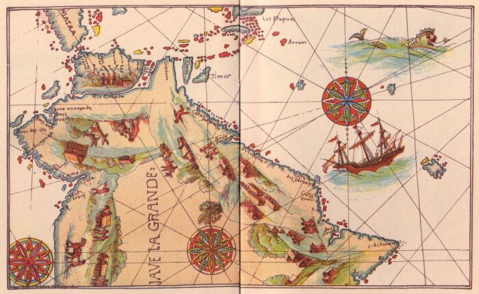
These maps show a large territory to the south of Timor and Java named ‘Java La Grande’ (Great Java). And as this large territory is roughly in the right place for Australia, there has been speculation that this was news that had seeped through from Portuguese mariners, active in that part of the world. True believers are also always ready to point out that many Portuguese records were lost in the catastrophic Lisbon earthquake of 1755 – as, indeed, was the case. There is also the simple truth that Portugal was sensibly secretive about its discoveries.
The problem is that the shores on the map do not bear any resemblance to Australia unless they are twisted at an angle – and naturally Portuguese enthusiasts have suggested that they should be! Likewise the illustrations of life in ‘Java the Great’ suggest temperate zones with no particularly Australian scenes: there is not even a drunken wallaby in sight.
It should though be remembered that Europeans had speculated for most of the sixteenth century about an antipodes, a great southern continent somewhere down in the Pacific, borrowing from classical ideas – Seneca and his black swans. They were as it happens right, but might their speculations also have led cartographers to have filled in the missing continent?
Worse still Java the Great might be a mistake coaxed out of a cartographer by a belief in a great southern continent.
Even with Beachcombing’s poor eyesight, he is struck by the basic similarity between Java and Java the Great on the map above. Isn’t it possible, as Prof Andrew Sharp suggested in the early 1960s, that Java the Great is just Java drawn to a much greater scale? All the signs are that two maps were combined and that two different versions of Java became a continent and an island on the copy.
Of course, none of this is to say that the Portuguese never made it to Australia: it is impressive enough that they got to nearby Timor. But there is no contemporary clue that they brought the news back with them to Europe. One of the facts that always strikes Beachcombing about the Age of Discovery is how many voyages are known about only because they were successful. If you went off to the horizon with three ships and never came back the chances are that you were lost to history.
***
4 April 2011: Tekno has this consideration: ‘I don’t think I could be the only one who is seeing here on the map not Australia, not even any part of Asia, but a remarkable similarity to South America. Even Caribbean islands seem to be on the right place. The discrepancies at Panama can be forgiven in the name of Artistic Liberty. 🙂 Maybe the whole map is another Voynich manuscript – 50% joke, 50% folly, and 50% mystery to curious people who are willing to pay.’ Thanks Tekno!!!


